SULAWESI ISLAND EXPOLER
- TRAVELLER TWO BROTHERS

- Jan 28, 2019
- 1 min read
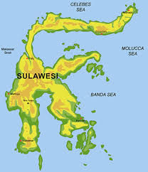
an island in Indonesia. Sulawesi is one of the four Great Sunda Islands, and is the eleventh largest island in the world, located east of Kalimantan, west of the Maluku Islands, and south of Mindanao and the Sulu Islands, Philippines. In Indonesia, only the islands of Sumatra, Kalimantan and Papua have a larger area, and only Java and Sumatra have more populations than Sulawesi.
WELCOME TO SULAWESI ISLAND
Governments in Sulawesi are divided into six provinces based on the order of their formation, namely the provinces of South Sulawesi, North Sulawesi, Central Sulawesi, Southeast Sulawesi, Gorontalo and West Sulawesi. Central Sulawesi is the largest province with a land area of 68,033 square kilometers and an area of sea reaching 189,480 square kilometers covering the eastern peninsula and part of the northern peninsula and the Togean Islands in Tomini Bay and islands in Banggai Islands in Tolo Bay. Most of the land in the province is mountainous (42.80% above the altitude of 500 meters above sea level) and Katopasa is the highest mountain with an altitude of 2,835 meters above sea level.
The following 10 major cities in Sulawesi are based on the population in 2010. [19]
Urutan Kota,
Population Province
1 Makassar, South Sulawesi 1,339,374
2 Manado, North Sulawesi 675,354
3 Kendari, Southeast Sulawesi 289,153
4 Palu, Sulawesi Tengah 335,297
5 Gorontalo, Gorontalo 1,097,990
6 Bitung, North Sulawesi 387,932
7 Palopo, South Sulawesi 148,033
8 Baubau, Southeast Sulawesi 137,118
9 Parepare, South Sulawesi 129,542
10 Kotamobagu, North Sulawesi 107,216


Comments